
A cursory look at this satellite view should make it obvious there were many challenges for those trying to make a living from the land in the Boolburra district west of Rockhampton, Queensland.
While some of the river-front land offered opportunity for crops and cattle, the risk from flooding was significant because of the fact that two large river systems join nearby.
This is better understood by looking at the second map image (see below) that shows the huge area of Queensland from which water flows via multiple gullies, creeks and tributaries.
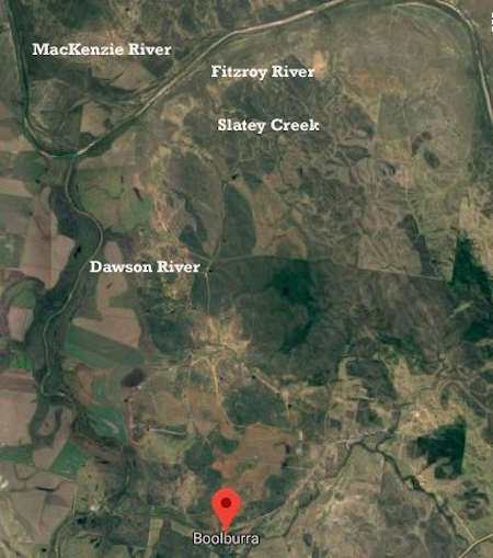
Satellite view of the Boolburra district which is near the confluence of the Dawson River and the MacKenzie River which then becomes the Fitzroy River.
Ultimately most of the water flows into the sea near Rockhampton.
So the point in the landscape where families such as my grandparents farmed was periodically under water.
Because water from the MacKenzie River usually reached the confluence point first, the Dawson River backed-up and spread out across the countryside.
The years 1918 and 1954 stand out as the two most significant events but there were many other times that brought damage and inconvenience. A fuller history is recorded at the Bureau of Meteorology website.
Which brings me to an account of one of these published in the Central Queensland Herald on Thursday 15 February 1951.
The Edungalba correspondent was a local, Mrs Olive Adams, whose husband Edward had property around Slatey Creek, right near the confluence of the MacKenzie and Dawson.
So the following report draws on that knowledge. The Norman Adams mentioned is her son. And, Mr A.Dobbs is my maternal grandfather, John Alexis Dobbs Coker, who at the time operated a dairy at Boolburra.
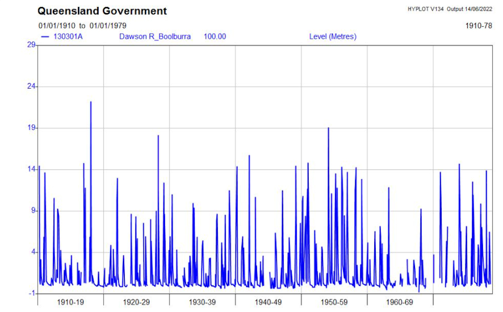
The graph of Dawson River height readings at Boolburra from 1910 to 1978. Pop Dobbs recorded the readings for 40-plus years. His adoptive father, Charles Dobbs. started taking readings in 1916. Note the highest peaks of 1918 and 1954. More details at this link.
EDUNGALBA
Now that the flood waters in the Dawson have subsided some estimate of the damage done can be made. As far as can be ascertained there was no serious loss of stock this side of the river, but many acres of good grass land were destroyed and miles of fencing were damaged.
Bad roads and flooded creeks caused much inconvenience to settlers in Sandy Creek and Boolburra districts, where cream and other supplies had to be boated across flooded creeks to reach the railhead.
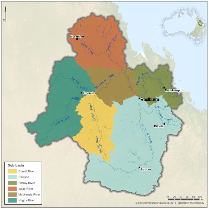
The Dawson-Fitzroy River system Queensland
At Boolburra the Dawson River rose to 48 ft 7 in. and Mr A. Dobbs (Post Office) moved his family out, but continued to visit the river daily and report the height to the Press.
At the junction of the Dawson, Mackenzie and Fitzroy Rivers, which occurs at Slatey Creek station, the full force of the flood was felt. Here the river reached the highest level since 1918.
Approximately 15,000 acres of choice grassland were inundated and destroyed in Mr E. Adams’ Slatey Creek and Mourangee properties and the cattle yards and dip were covered by 14 ft of water. Flood waters backed up to a depth of 18 in. under Mr Norman Adams’ home at Slatey Creek, causing him to move his family to safety.
On the Mackenzie River one well-known stock owner reported that he had 1200 cattle trapped by floodwaters, but has since heard that all but 120 of them are safe. Many of these cattle had been swept 30 miles down stream and landed safely there.
It is marvellous just how far grown cattle can drift in flooded waters without drowning. The greatest loss occurs with calves and weaners. Many of the former swim round their partly submerged mothers, until they become exhausted and are swept away and drowned.
During January, 1129 points of rain fell and February has so far yielded 96 points. Sandflies and mosquitoes are very troublesome. Smoke fires have to be kept burning in order to give the stock some respite from their attentions.
APA citation [?]LBA (1951, February 15). The Central Queensland Herald (Rockhampton, Qld.: 1930 – 1956), p. 23. Retrieved November 5, 2019, from http://nla.gov.au/nla.news-article7557303
Alex Dobbs honoured
In 1986, Alex Dobbs received a gold watch for his contribution to his community.
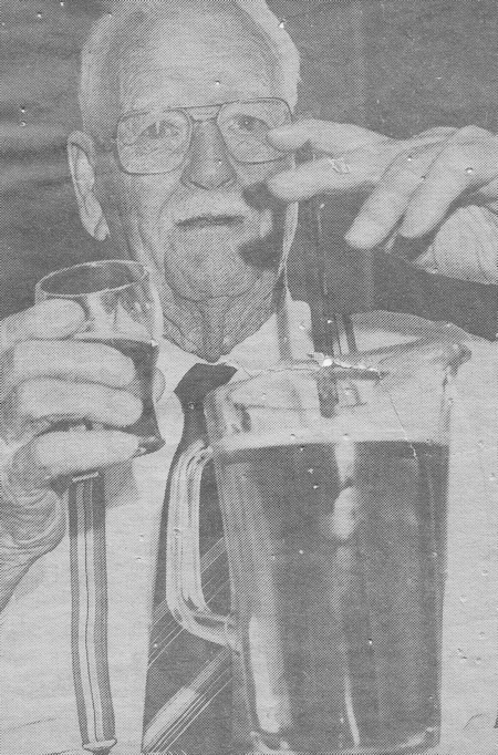
Newspaper image of the presentation.
The text from the newspaper report of the award follows:
It might not be the liquid Mr Alexis Dobbs (pictured) is used to but after 41 years of measuring water, beer made quite a change.
Mr Dobbs, who measured river levels daily from 1937 to 1978, was presented with a gold watch yesterday by the Queensland Water Resources Commission.
He was also given a complete list of the dates his family had collected in three bound volumes. The original water resources gauge was built in 1909 at Boolburra on the Dawson River, 97km west of Rockhampton.
The Dobbs family started taking readings in 1916. As well as taking daily river heights, Mr Dobbs took flood readings and passed the information on to property owners, the Rockhampton City Council, the harbour board and police.
Boolburra is a railway siding, and Mr Dobbs and his wife also operated a telephone exchange.
Water Resources director Mr John Ward made the presentation at Rockhampton Masonic Club.